
Geographic Information System for Managing Natural and Historical Tourism in Sara Buri Province
Article Sidebar
Main Article Content
Abstract
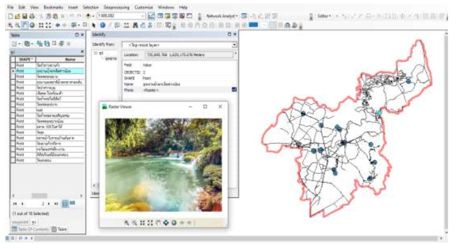
This research aimed to (1) create a database of natural and historical tourist attractions and (2) determine optimal travel routes in Saraburi Province. Location data were collected using the Global Positioning System (GPS), and the database was developed with ArcGIS Version 10.5. The Network Analysis tool was employed to identify optimal the travel routes to the selected attractions. The resulting database consists of spatial data showing geographic locations and attribute data providing descriptions and images of each site. A total of five travel routes were identified, comprising two natural and three historical routes: Natural Tourist Routes: No.1 “Embrace Nature” – 82 kilometers, 8 hours 25 minutes No.2 “Trekking, Camping, and Stargazing” – 65 kilometers, 43 minutes Historical Tourist Routes: 1) “Pay Respect, Make Merit, and Retrace History” – 65 kilometers, 5 hours 13 minutes 2) “Enjoy Souvenir Shopping in Sao Hai District” – 6.5 kilometers, 5 hours 4 minutes 3) “Visit Temples and Pay Respect to the Buddha’s Footprint” – 132 kilometers, 8 hours 18 minutes. This study emphasizes the effectiveness of Geographic Information System (GIS), particularly through Network Analysis, in supporting efficient travel planning and promoting sustainable tourism development in Sara Buri Province.
Article Details
References
ณรงค์ พลีรักษ์. (2556). ระบบสารสนเทศทางภูมิศาสตร์เพื่อจัดการการท่องเที่ยวชุมชนในจังหวัดชลบุรี. วารสาร
วิจัยและพัฒนา มจธ., 36(2), 235–248.
ธัญญรัตน ไชยคราม. (2561). การประยุกต์ระบบสารสนเทศภูมิศาสตร์เพื่อวิเคราะห์เส้นทางการท่องเที่ยว เขต
พื้นที่ 12 เมือง ต้องห้าม...พลาด ในกลุ่มการท่องเที่ยวภาคกลาง. วารสารวิทยาศาสตร์และเทคโนโลยี.
(7), 1116-1129.
นุจรินทร์ ปทุมพงษ์, และโชคชัย ถมทอง. (2561). การพัฒนาระบบสารสนเทศภูมิศาสตรเพื่อจัดการสถานที่
ท่องเที่ยวทางประวัตศาสตร์ จังหวัดกําแพงเพชร. สักทอง : วารสารวิทยาศาสตร์และเทคโนโลยี (สทวท.).
(1): 63-72.
สำนักงานจังหวัดสระบุรี. 2566. แผนพัฒนาจังหวัดสระบุรี พ.ศ.2566-2570.
https://www.saraburi.go.th/web2/files/com_strategy/202111_f8f5bfa97e21c4b.pdf?utm_s
ource=chatgpt.com. สืบค้นเมื่อ 20 เมษายน 2568.
สุเพชร จิรขจรกุล. (2560). เรียนรู้ระบบภูมิสารสนเทศด้วยโปรแกรม ArcGIS Desktop 10.5 for Desktop,
บริษัท เอ.พี. กราฟิคีไซน์และการพิมพ์, กรุงเทพฯ.
อารีรัตน์ ชูพันธ์, และเสาวคนธ์ ชูบัว. (2565). การพัฒนาระบบสารสนเทศภูมิศาสตร์เพื่อสนับสนุนการท่องเที่ยวใน
ชุมชน. อำเภอขนอม จังหวัดนครศรีธรรมราช. วารสารวิชาการการประยุกต์ใช้เทคโนโลยีสารสนเทศ,
(1): 19-30.
Çolak, H., & Donmez, M. (2024). GIS-based daily tourism route proposal for surrounding
provinces and districts from Ankara’s Çankaya district. Environment, Development and
Sustainability. https://doi.org/10.1007/s10668-023-03664-3
Goodchild, M. F. (2018). Reimagining the history of GIS. Annals of GIS, 24(1), 1–8.
https://doi.org/10.1080/19475683.2018.1424737
Granja-Martins, F. M., & Fernandez, H. M. (2024). Geographic Information System in the
Optimization of Tourist Routes in the City of Faro (Algarve, Portugal). Urban Science, 8(3),
https://doi.org/10.3390/urbansci8030123
Moreno-Gil, S., López, A., Pérez, M., & Díaz, R. (2021). GIS approach applied to tourist bus route
design on Lanzarote Island. Sustainability, 13(19), 10671.
https://doi.org/10.3390/su131910671
Kiriwongwattana, K., & Waiyasusri, K. (2024). Spatial evolution of smart cities for sustainable
tourism: A case study of Phuket Province, Thailand. Geojournal of
Tourism and Geosites, 55(3), 1312–1320. https://doi.org/10.30892/gtg.55331-1303
Soltesova, M., Iannaccone, B., Strba, L., & Sidor, C. (2025). Application of GIS technologies in
tourism planning and sustainable development: A case study of Gelnica. ISPRS
International Journal of Geo-Information, 14(3), 120. https://doi.org/10.3390/ijgi14030120
